Product Overview

NovaRisk™ is an AI-driven platform for real-time environmental risk analytics using satellite data. Built for insurance underwriting, claims validation, and ESG reporting.

Who It’s For

• Insurance carriers and MGAs
• Reinsurers and catastrophe modellers
• ESG asset managers
• Risk analysts and compliance teams

Pricing Plan

• Starter Plan
• Pro Plan
• Enterprise

Please contact us to get your quote.

Key Features

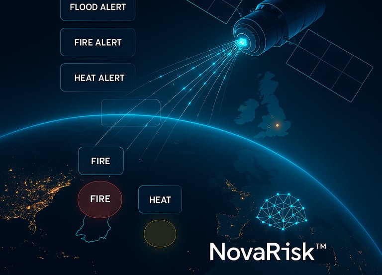
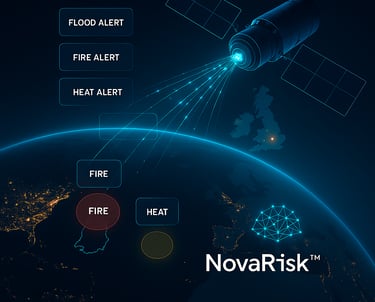
• 🌊 Real-time flood, fire, heat, and subsidence alerts
• 🛰️ Satellite change detection for claims (NovaClaims AI™)
• ♻️ ESG exposure scoring and dashboards (OrbitScore™, NovaESG™)
• 📍 Asset-level mapping via API and dashboards
• ⚖️ Compliance with FCA/PRA climate regulations

Satellite Insights Solutions

Harness AI and satellite data for smarter climate risk management and insurance automation.

A glowing blue digital representation of the Earth is depicted, highlighting continents with illuminated contour lines against a black starry background. Small lights appear scattered across the surface, resembling cities or data points.
A mesmerizing satellite image captures a dramatic view of Earth's natural formations. Bright turquoise seas act as a striking contrast against deep blue waters, showing swirling patterns that resemble ocean currents or algae blooms. In the lower part, rugged red and orange landmasses highlight the coastline, offering a vivid display of geographical features.
Real-Time Monitoring

Detect floods, fires, and environmental threats instantly with our advanced Earth observation technology.

Automated Compliance

Ensure ESG compliance effortlessly through our innovative solutions tailored for financial institutions and insurers.

Climate Insights

AI-driven satellite data for smarter climate risk management.

A satellite view of a rugged, mountainous landscape with intricate patterns of ridges and valleys. The terrain is covered in snow, creating a light blue and white palette. There are visible rivers and streams cutting through the land, adding contrast to the snowy expanses.
Flood Detection

Real-time monitoring for effective risk assessment and management.

A remote weather station is situated in a vast, snowy landscape. Majestic snow-covered mountains rise in the background under a partly cloudy sky. The station is equipped with various antennas and instruments, perched on a flat expanse of ice, with a small red flag marking the area.
A large satellite dish covered in ice and snow is set against a clear blue sky. The ice creates intricate patterns on the surface and structure of the dish, highlighting the cold weather conditions. The aerials and supporting structures are also encrusted with frost.
A vibrant satellite image showcasing a geological formation with swirling patterns. The landscape features a mix of rugged textures and undulating contours, with colors ranging from deep reds and purples to bright yellows and greens. The central area appears to be a circular crater-like structure.
Fire Alerts

Instant alerts for fire threats using satellite technology.